15 Essential Bridge Equipment On A Merchant Ship
The control and navigation of the ship is carried out on the bridge. Therefore, various equipment is located on the bridge of a merchant ship for the safety of the ship and crew and record keeping. Here is a detailed description of bridge equipment and its uses.
Different bridge equipment is required to safely navigate the ship while dealing with complex traffic, visibility, and water conditions.
So, ships have this equipment to capture and track other ships, monitor their progress, check the depth below the ship, communicate with other ships and shore, send and receive messages to and from the ship and shore, and send and receive required data.
Bridge equipment has various uses. Some bridge equipment, such as VHF, MF/HF, and SAT-C, is used for communication, while others, like radar and dashcam, are used for collision avoidance.
Bridge equipment like ECDIS prevents grounding. Below are the essential equipment and controls on the bridge of every merchant ship.
1.GPS
This is nothing new these days. All smartphones are equipped with GPS, and we all know how to use it. The GPS in your smartphone is accurate and can take you anywhere in the world without any major errors.
Similarly, on board, we have GPS in our bridge equipment. The only difference is that we have a separate GPS unit on the bridge that provides information to all other specialized equipment on board.

GPS stands for Global Positioning System. GPS provides the fastest and most accurate way for navigators to determine their current position and speed on the earth.
Basically, GPS consists of three segments: the space segment (consisting of satellites), the control segment (control station), and the user segment.
While the United States Air Force uses and operates the first two segments, the user segment is us, the users.
The space segment consists of satellites that transmit radio signals to the users.
List Of Warehouse Material Handling Equipment (MHE) Used for Cargo
The control segment consists of ground stations that track GPS satellites, monitor their signals, and send commands and data to the satellite network.
The GPS receiver on the ship calculates the position by measuring the distance from the satellites. This simply means that the receiver receives the signal from the satellite and then calculates the distance between the satellite and the receiver.
Now, the receiver is far from one satellite, and it receives signals from 3 or 4 GPS satellites simultaneously.
In this way, the receiver calculates the distances of all these satellites, and then, by intersecting the distance fields, we get the three-dimensional position of the ship on Earth.
2. ECDIS
ECDIS stands for Electronic Chart Display and Information System. This means that the cards and related information are stored and displayed to us in a digital format.
ECDIS is an anti-grounding tool mainly used to monitor the ship’s progress along the route.
ECDIS receives information from at least three bridge devices. They are GPS, log and gyro.
The GPS provides the position, while the gyro provides the ship’s direction. The ECDIS log provides the ship’s speed.

Once the navigation plan is prepared and the route is defined in ECDIS, the ship’s position is displayed in ECDIS.
All we have to do is monitor the ship’s progress and confirm its position using various available means.
In ancient times, sailors navigated using paper maps. Paper charts contained the necessary information indicating the depth of the area covered.
The biggest disadvantage of charts is that a large number must be kept on board, and the card paper must be updated.
When a ship receives weekly chart corrections, all charts must be corrected manually. All letters must be corrected manually, which is time-consuming and prone to human errors.
With the introduction of ECDIS, the possibility of human errors has been minimized, which saves time.
But now, when a ship receives weekly chart corrections, ECDIS charts can be corrected in less than a second.
3. Radar
Radar is installed on ships to avoid collisions. It is mainly used for monitoring to assist safe navigation and prevent collisions by providing the location of other ships, land, visible navigation hazards, and other objects.
Radar consists of four units: a scanning unit, a receiving unit, a scanning unit and a display unit.
The transmitter sends signals (pulses of electromagnetic energy) through the scanner.
These pulses hit the target and returned to the receiver. The receiver processes these signals and displays them on the display unit as dots.
The size of the dots depends on the size of the target. The larger the target, the larger the dot.
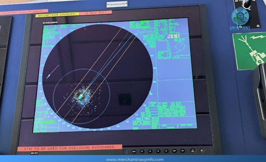
There are two types of radars, depending on the wavelength. X-band radar has a wavelength of about 3 cm (9.2-9.5 GHz), while S-band radar has a wavelength of about 10 cm (2.9-3.1 GHz).
Every ship is usually equipped with an X-band radar because it is good at detecting small objects nearby. It is also useful in search and rescue situations because only X-band radars can detect SART signals.
On the other hand, S-band radars are good for long-range detection. So, if two radars are installed on a ship, one can be an S-band, and one can be an X-band.
4. Automated Artificial Intelligence System
AIS stands for Automatic Identification System. It is essentially a broadcast system that transmits the provided data to surrounding ships and other AIS receivers in the area, including VTS and other receivers.
While other ships may use it only as a navigation aid, VTS uses AIS to obtain ship data and monitor in their area.
The data sent in AIS is divided into three types. The types are:
- Static data
- Dynamic data
- Trip-related data
Static data contains standard data that the operator cannot change. It includes the vessel name, call sign, vessel type, vessel length and beam, IMO number, antenna position, and MMSI number.
Whereas dynamic data is the data sent to you by other sensors and includes the vessel’s position, direction and heading above the bottom.
What are the Causes Of Equipment and Machinery Breakdown Onboard the Ship?
Voyage related data is the data that the operator has to send when any data changes. Voyage data includes vessel status, destination, estimated time of arrival and cargo type.

AIS operates on VHF frequencies (Ship-to-Ship channel 87B and Ship-to-Shore channel 88B). This means there will be one VHF transmitter and two VHF receivers.
The AIS system operates based on SOTDMA technology, which stands for Self-Organizing Time Division Multiple Access.
The AIS slot frame provided consists of 2,250 available slots in a one-minute time frame. So, our AIS will search for an available slot in the slot frame, and the transmitter will send the data in the specified time interval.
As all this works automatically, it is called self-adjusting TDMA.
5. Echo Sounder
Since the ship is sailing on the water, we cannot see the depth under the water. Therefore, some equipment must show the depth under our ship so that we can sail safely without the risk of running aground.
However, the water depth is already marked on the nautical chart, but there must be some way to verify the accuracy of the given depth.
Therefore, the ship is equipped with an echo sounder to determine the depth below the keel. This is the most important bridge equipment to avoid grounding.
Echo devices can be of different types and brands, but they all work on the same principle.
This means that the transducer transmits sound/acoustic waves to the seafloor, which then hit the seafloor and return to the receiver.

The speed of these waves is equal to the speed of light. Therefore, the time it takes for the transducer to reach the receiver is known.
Therefore, the depth is automatically calculated using the formula distance = speed x time/2.
The depth is then displayed to us digitally or automatically on a paper chart, which can be used to show the depth.
Speed Log
Speed registers are provided in the bridge equipment to measure the ship’s speed. The speed logs available on board can be of different types, including Doppler logs, electromagnetic logs, and several others.
Doppler logs are commonly found on merchant ships. It uses Doppler shift to measure the frequency.
This means that a pulse of known frequency is transmitted to the seafloor and then reflected to the ship.
Then, we know the difference between the transmitted and received frequencies, which is proportional to the ship’s speed.
Doppler logs show the speed over land and the speed in water.

When the depth under the beam is less than 200 meters, the pulse hits the seafloor and returns to the sensor. The calculated speed is called the speed over the ground.
On the other hand, if the depth is more than 200 meters, the pulse returns from 10 to 30 meters of water. The calculated speed will be the speed through the water.
7. VHF and MF/HF
VHF and MF/HF are bridge equipment used for communication purposes.
VHF can be used for shorter ranges up to 50 nautical miles, while MF/HF can be used for longer ranges. MF/HF can be used up to 200 nautical miles.
VHF and MF/HF are mainly used for ship-to-ship or ship-to-shore calls.
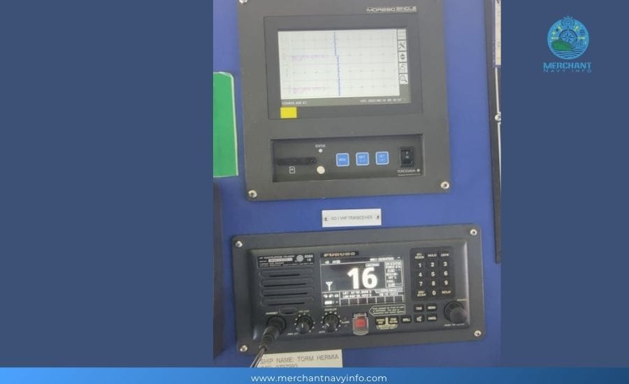
The bridge equipment can also receive, send and receive messages, and transmit general, safety, emergency and distress messages.
DSC (Digital Selective Calling) facilities are provided in the equipment to establish initial communications between ships and other ships, ships and shore, or shore and ships.
DSC is used to transmit information to other ships or coast stations digitally.
8. SAT-C
The SAT-C is installed on the bridge and is used to receive maritime safety, distress and emergency messages and transmit emails to any email address.
SAT-C is fully compatible with GMDSS. The SAT-C equipment also has a dedicated distress button to transmit distress signals directly from the bridge equipment.

Thus, SAT-C provides towpath messaging, distress calls, data reporting, and EGC services.
SAT-C sends messages between ship-to-ship, ship-to-shore, and shore-to-ship facilities.
9. Autopilot System
The autopilot system steers the vessel in autopilot mode on the high seas without any manual steering.
Manual steering is necessary when the vessel is in closed or pilotage waters. On the other hand, when the vessel is sailing on the high seas, manual steering becomes difficult after a long time.
Therefore, an autopilot system is provided so that the vessel can be steered automatically. The gyroscope or magnetic compass on board the vessel determines the route being guided.

The operator selects the path to be guided, which can then be changed by the path selection knob.
The autopilot system maintains the heading and can also make heading adjustments.
The autopilot system has different settings that can only be changed by trained operators. These include rudder settings, weather settings, and other rudder settings, including rudder control, anti-rudder, turn rate settings, and PID control.
10. BNWAS
BNWAS stands for Bridge Watch Navigation Alarm System. It is installed for the safety of the ship and crew.
When the watch guard or probation officer is on duty alone, and something happens, he cannot man the ship or take any evasive action.
Hence, he is unfit for duty, but if the crew under the bridge is not aware of the situation and a mishap occurs, it may endanger the lives of all.
Hence, to maintain the safety of the ship and crew, a bridge device called BNWAS is installed on the ship so that when the watch guard is sick, tired or unwell for any other reason, the alarm system can alert other support staff/captains.

The alarm system first alerts the probation officer, who can reset the alarm. But if the officer on duty cannot reset the alarm on the bridge, he alerts other designated persons/captains in his cabin.
So that the captain or the reserve officer can reach the bridge and handle the situation.
The alarm system should… The only thing is that the data should be saved within a time limit so that it can be saved in a separate drive and accessed later.
It has to retain the data for at least 12 hours, and it must be available once saved.
VDR stands for Flight Data Recorder. This means that it records and maintains all the data required by the regulations.
The data sources are taken from the relevant equipment and include radar images, echo sounders, bridge sounds, VHF sounds, ship direction and speed, engine arrangement and response, rudder arrangement and response, wind speed and direction, date, time, and position.
The Voyage Data Recorder on a ship can be of two types – namely
- VDR (Flight Data Recorder)
- – SVDR (Simplified Flight Data Recorder)
The only difference between them is the amount of data they store. VDR stores more data, while SVDR stores only the data required by the regulations.
SVDR stores data such as bridge, VHF audio, date, time, position, ship direction and speed, and radar image.
12. Off course Alarm System
The lane departure warning system is connected to the autopilot system. An audio and visual warning will be issued when the current path deviates from the specified path.
Assume the ship is in autopilot state, and we set the heading to 050 degrees. The lane departure alarm is set to 5 degrees. Due to some external or internal factors, the ship’s direction changes by more than 5 degrees.
If the ship’s heading exceeds 055° or 045°, the heading deviation alarm will sound and notify the duty officer.
Therefore, the heading deviation warning system can help the duty officer understand whether the ship is sailing according to the intended course.
13. Gyrocompass and magnetic compass
As we explained in the previous article, gyroscopes and magnetic compasses are installed in the bridge equipment to provide the ship with gyroscopic and magnetic directions.
The direction of the gyroscope has nothing to do with the ship’s magnetism. The ship’s magnetic direction changes, and therefore, it has to be corrected based on its position on the ground.
A gyrocompass is used to determine the direction of the ship by non-magnetic means. The captain must be clear about the direction and provide feed for other required equipment.
Gyrocompass can provide the direction of a 360-degree arc on the horizon.
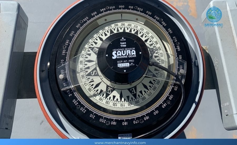
A magnetic compass has a magnetic needle which aligns with the earth’s magnetic field and gives us the magnetic direction of the ship.
The magnetic direction depends on the position of the ship, the hull, and the magnetic compass on the ship.
14. Track recorder
This bridge equipment automatically records the course of the ship. The track can be recorded on paper or digitally.
The recording is made so that it can serve as evidence of the ship’s course.
The track recorder is mainly useful in case of an accident or grounding. It allows for verification and investigation of the ship’s course.
The track recorder records the track and records the date and time stamp at repeated intervals.
15. Steering system
The steering system is the system on the bridge that controls and changes the course of the ship. It includes the steering gear, steering gear power unit, steering gear, and other related machinery.
While all other machinery is located in the steering gear room, the steering gear and steering wheel control is provided on the bridge.
Under normal circumstances, the ship is steered from the bridge, so the steering control, steering motor, start and stop control, steering wheel and fault alarm are associated with the steering gear.
The rudder can be turned from 0 to 35 degrees to port and starboard. When steering is performed from the bridge, electrical and mechanical means transmit the steering to the rudder.
The rudder is then moved at the desired angle, displayed on the bridge’s rudder angle mark.
