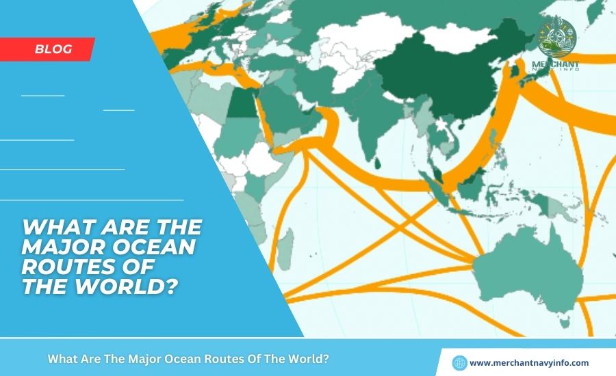
Major sea routes of the world, or waterways, are the lifeblood of international trade around the world. According to the International Maritime Organization. The oceans connect the world and also drive economies, with 90% of global trade passing through waterways. Major sea routes of the world can be either natural or man-made. And are also designed to deliver cargo shipments in the shortest, safest, and most efficient way. They often connect central ports and transshipment points along oceans, seas, and rivers.
Some shipping routes are busier and also more important than others. Because they connect countries and continents, reduce transportation costs, and also save time. The busiest shipping lanes are evidence of the growth of the global shipping network. Advances in maritime technology, and modern port infrastructure that allows smooth maritime operations.
Major Sea Routes Of The World
1. Panama Canal
This man-made canal is considered one of the world’s busiest and most important Major sea routes of the world. It is 82 kilometres or 51 miles long and connects the Atlantic and Pacific Oceans across the Isthmus of Panama. Without the canal, ships would have to detour around Cape Horn and the southern tip of South America. Thus, the Panama Canal saves at least 2000-8000 nautical miles on each voyage. The Panama Canal enables maritime trade between Asia and also the United States, and especially between Asia and ports on the East Coast of the United States. Approximately 12,000-15,000 ships pass through the Panama Canal each year.
Its construction was difficult, beginning 119 years ago in 1904 and was completed in 1914. During construction, Colombia, France, and also the United States controlled the surrounding area. In 1881, France began work on this strategic project but was forced to halt due to the technical problems engineers faced. And also the high mortality rate of workers. In 1904, the United States. Took over this arduous task and managed the Canal and also Canal Zone. Until it was handed over to Panamana in 1999. It is now operated by the Panama Canal Authority. The first set of locks was 33.5 m wide, and a third set of wider locks was constructed between 2007 and 2016. Allowing larger NeoPanamax ships to pass through the canal.
2. Suez Canal Route
This artificial waterway is one of the most popular Major sea routes of the world, connecting the Mediterranean Sea to the Red Sea via the Isthmus of Suez. This 193.30 km long seaway is the fastest and most direct route for maritime trade between Europe and Asia. Construction began 164 years ago in 1858 and finished 154 years ago in 1869.
In 2020, about 19,000 ships passed through the Suez Canal, accounting for 12% of world trade and 30% of the world’s container traffic. It is an important route for transporting oil and hydrocarbons from Asia and the Middle East to European countries. Apart from the main transport goods, such as energy, parts, and consumer goods, about 7-8% of the world’s oil and 8% of liquefied natural gas pass through the Suez Canal. Due to the high volume of trade between Europe and Asia, the route remains very congested, causing occasional traffic jams, such as in 2021, that impede global trade.
3. Strait of Dover or the English Channel
The Strait of Dover is located at its narrowest. It is the tip of the English Channel and marks the boundary between the English Channel and the North Sea. It also separates the United Kingdom from mainland Europe. The Strait of Dover is in French and British territorial waters. However, the United Nations Convention on the Law of the Sea allows ships of other countries to navigate the waterway freely.
On a clear day, you can see the British coast from France and vice versa with the naked eye. The most famous sights are the White Cliffs of Dover, the coastal buildings on both coasts and the lights on both coasts at night. Most ships travelling between the Atlantic, the North Sea and the Baltic Sea pass through this Strait instead of taking the longer and more dangerous route around the north of Scotland.
4. St. Lawrence Seaway
The St. Lawrence Seaway, about 600 km long, is the fastest shipping route between the waters of the United States and Canada, especially the northern regions of Canada. The seaway is a system of locks, canals, and channels that serve small ports directly, allowing cargo to reach its final destination without loading at large, distant port facilities.
It allows ships to travel from the Atlantic Ocean to the Great Lakes of North America and inland to Duluth (Minnesota). It is named after the St. Lawrence River, which flows from Lake Ontario into the Atlantic Ocean. Stretches 1,900 miles from Lake Ontario to New York, reaching ports in Wisconsin, Ontario, Vermont, Michigan, Illinois, Ohio, and more. About 40 to 50 million tons of cargo pass through here annually, including bulk cargo, general cargo, iron ore, minerals, grains, etc.
5. Straits of Malacca
The Straits of Malacca, 800 km long and 65 to 250 km wide, lies between Sumatra and the Malay Peninsula. It is the most important waterway between the Indian and Pacific Oceans and therefore a vital sea route to Asia. It connects Asia’s three major economies, India, Japan and China, with other countries in the region, such as Indonesia, Malaysia, Singapore, South Korea, Taiwan, Malaysia and Thailand.
About a quarter of the world’s maritime trade passed through this route on 50,000 ships. The main traded goods were Indonesian coffee, coal, palm oil, machinery, industrial products and processed foods. It also provided the shortest route between the Persian Gulf and Asian countries, allowing the transportation of large amounts of oil. According to the U.S. Energy Information Administration, about 61% of oil production passes through this route, making it the second largest oil trading control point in the world.
6. Strait of Hormuz
The Strait of Hormuz connects the Gulf of Oman with the Persian Gulf, speeding up the transportation of goods, especially oil. It is the only sea route from the Persian Gulf to the open sea, making it a strategic maritime bottleneck. Crucial for Asian countries such as India, Japan, China, South Korea and Singapore, which conduct most of their maritime trade from there. It is 167 km long and 96-39 km wide. On the northern bank of the Strait lies Iran, and on the southern bank lies the Musaddam Peninsula.
7. Strait of Gibraltar
The Strait of Gibraltar is a natural link between the Atlantic Ocean and the Mediterranean Sea and is one of the busiest shipping routes. At its narrowest point, between Cape Marroqui in Spain and Cape Seal in Morocco, it separates Europe and Africa by a 13 km channel. Ferries cross the two continents in about 30-40 minutes. The Strait lies within the territorial waters of Spain, Morocco and Gibraltar, but international ships and aircraft can pass freely through it in accordance with the United Nations Convention on the Law of the Sea.
8. Denmark Strait
The Denmark Strait connects the Baltic Sea with the North Sea. Throughout history, it has been used as an internal passage for Denmark. After the loss of territory, the Fehmarnbelt and resund are still shared with Germany and Sweden. The Great Belt and the Little Belt are still part of Danish territorial waters. The Strait has been considered an international sea route since it was opened to commercial shipping activity by the Treaty of Copenhagen in 1857.
9. Bosphorus
The Bosphorus is a natural strait in northwestern Turkey that connects the Black Sea with the Sea of Marmara. Also known as the Strait of Istanbul, it connects the European and Asian parts of Turkiye. It is a strategic waterway that has played an important role in trade for centuries. The waterway is 31 km long, and its width only varies between 730 and 3300 meters. It is important from a commercial and military point of view, as it provides an important maritime access route for several countries, including Ukraine and Russia.
10. Transpacific Route
This route connects Asia with North and South America. A wide range of goods are transported on this route, including electronics, machinery, and textiles. It runs through the Pacific Ocean and has major ports such as Tokyo, Shanghai, Long Beach, Los Angeles, and Vancouver.
Conclusion
All the major shipping routes in the world enable the smooth and efficient flow of goods and services between continents, allowing businesses and companies to enter new markets and enabling consumers to source goods produced on the other side of the globe. Knowing and understanding these shipping routes helps those involved in trade and transportation to make informed decisions about logistics and transportation, optimize their operations, attract more customers and remain competitive in their industries.